Key Takeaways
Construction drone services can support better decisions from early site planning through to completion. Their value depends on clear objectives, consistent capture and careful integration with existing project records.
- Establish a reliable visual baseline before construction begins.
- Use mapping, measurements and imagery for planning and coordination.
- Capture repeatable progress updates against programme milestones.
- Inspect difficult areas while reducing unnecessary exposure to height.
- Choose an appropriately licensed provider with clear deliverables.
What construction drone services include
Construction drone services cover more than occasional aerial photographs. Depending on the brief, a provider may collect visual records, map a site, measure changes or inspect areas that are difficult to access. The useful output is not simply impressive footage; it is information that fits the way a project team plans, reports and makes decisions. For an overview of planning and capture, this construction drone photography guide is a useful companion resource.
Aerial photography and videography
High-resolution stills and video provide a broad view of a project that is difficult to achieve from ground level. They can show access routes, work fronts, stored materials, temporary works and the relationship between different areas of a site. A consistent camera position and flight path also make later comparisons more meaningful. The strongest briefs specify whether the material is intended for project reporting, stakeholder updates, marketing or an evidentiary record.
Orthomosaic mapping and 3D modelling
An orthomosaic combines overlapping aerial images into a scaled visual representation of the site, while 3D modelling adds depth and form to the captured information. These outputs can help teams understand site layout, communicate design intent and review changing conditions. Accuracy depends on factors such as flight planning, ground control, image overlap and processing, so the provider should explain the method and expected tolerances rather than simply promise a model.
Topographic surveys and site measurements
Aerial surveys can support an understanding of levels, boundaries, stockpiles, haul roads and earthworks. They are most useful when the required measurement, coordinate system and deliverable format are agreed before the flight. Survey-grade requirements may call for additional controls or verification by an appropriately qualified professional. Drone data should complement, not silently replace, the survey information required for contractual or statutory purposes.
Thermal, infrared and specialist inspections
Specialist sensors can reveal patterns that are not obvious in standard colour imagery. Thermal or infrared capture may assist with investigation of heat differences, moisture-related concerns or building services, provided the conditions and equipment are suitable. Interpretation matters as much as capture: a coloured image is not automatically a diagnosis. Ask for the relevant limitations, supporting observations and a clear explanation of what the inspection can and cannot establish.
How drones improve construction site planning
Planning benefits when the project team can see the whole site before access, earthworks and temporary arrangements become fixed. Aerial data can connect drawings with actual conditions, giving designers and site managers a shared reference. It also creates a dated record that can be revisited when assumptions are questioned later. This aerial planning resource outlines practical considerations such as flight paths, capture schedules and coordination with site managers.
Establishing accurate pre-construction baselines
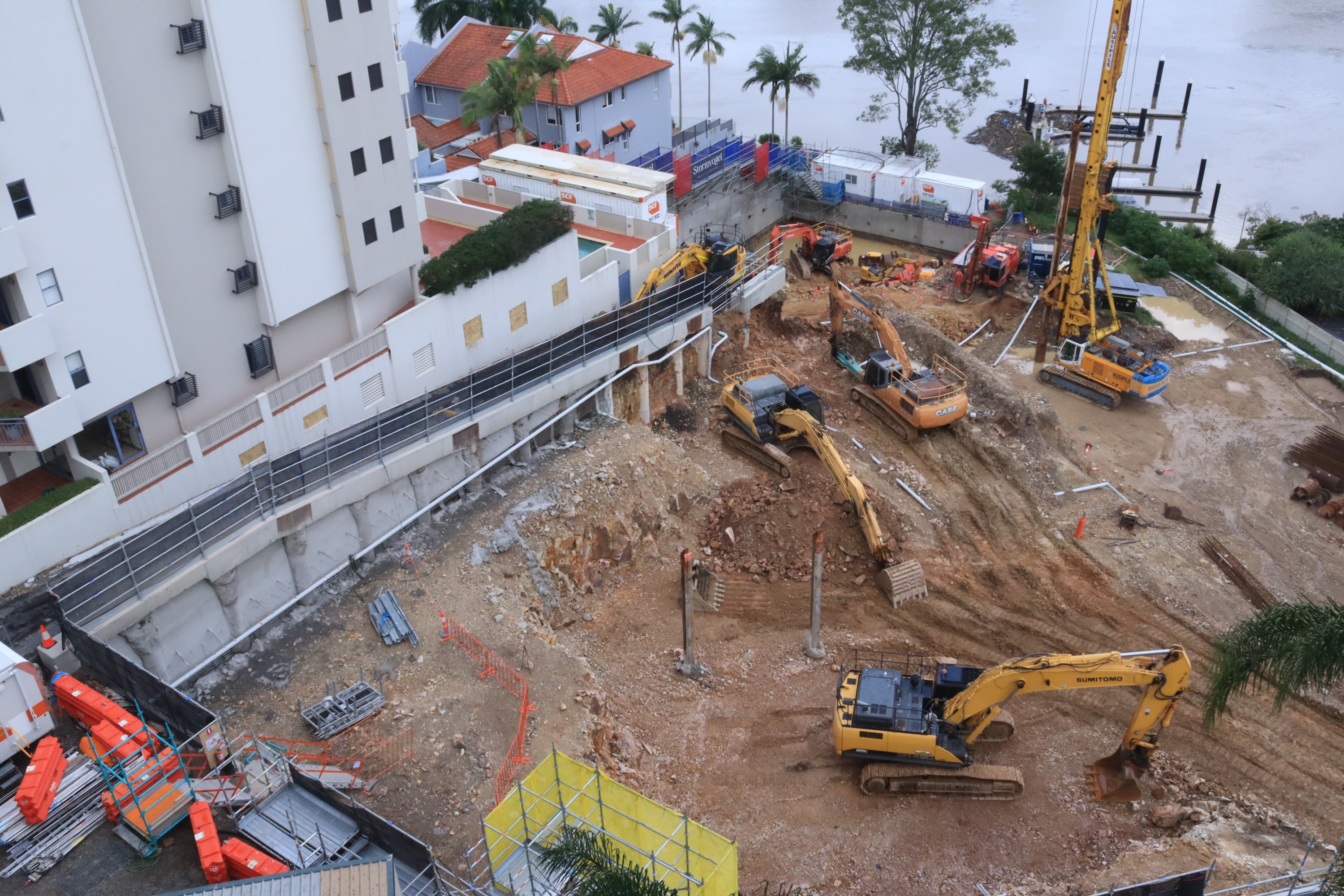
A baseline records the condition of the site before major works alter it. It may include neighbouring structures, existing surfaces, vegetation, access points, drainage features and surrounding land uses. Capturing these details early gives the project a common starting point for progress comparisons and later investigations. The baseline should be labelled with its date, location and scope so it remains useful beyond the day it was created.
Assessing terrain, access and drainage conditions
Aerial imagery helps teams review how vehicles and equipment will move through the site, where materials may be stored and how water appears to travel across the ground. It cannot replace detailed civil design or hydrological assessment, but it can expose practical questions early. A higher viewpoint may also reveal constraints at the edges of a site that are easy to miss during a walk-through.
Supporting design coordination and feasibility studies
Designers, estimators and constructors often work from different drawings and assumptions. A current aerial record provides a shared visual layer for discussing staging, crane positions, laydown areas and interfaces with existing assets. It can be especially useful during feasibility work, when the team needs to test several options before committing to a detailed solution. The output should be named and stored in a way that makes the relevant revision obvious.
Identifying risks before earthworks begin
Early imagery can highlight unstable access, nearby public areas, overhead constraints, exposed edges and potential conflicts between proposed work zones. It should feed into the project’s normal risk process rather than sit as a separate visual exercise. A simple pre-flight and pre-works review can ask who may be affected, what needs protection and which observations require on-ground verification.
Using drones to monitor construction progress
Progress monitoring works best as a repeatable process rather than a series of unrelated flights. The team should decide what will be captured, from which positions and at what interval before the first update. Consistency makes change easier to see and reduces debate about whether an apparent difference is simply a change in angle or weather. For broader visual monitoring, Construction Time Lapse Specialists describes aerial photography, mapping, surveying and inspection services alongside other project imagery.
Capturing consistent site updates
A repeatable route, altitude, camera direction and capture schedule create a more dependable visual record. Updates can then show changes in excavation, structure, façades, services, roads and landscaping without requiring every stakeholder to visit the site. The operator should coordinate with the site team so flights do not interfere with lifting operations, deliveries or other controlled activities. File names and dates are small details, but they save time when records accumulate.
Comparing progress against plans and schedules
Aerial images become more useful when they are reviewed against the programme and relevant drawings. A project manager can look at whether a work front has started, whether an area is ready for the next trade and whether access or storage is affecting sequence. The images do not prove productivity on their own, but they provide context for conversations about delay, coordination and incomplete work. Where measurements matter, the corresponding mapped output and stated accuracy should be retained with the image set.
Documenting milestones for clients and stakeholders
Milestone imagery gives clients, consultants and government stakeholders a concise way to understand what has changed since the previous report. It can support presentations, payment discussions and formal progress reporting when accompanied by dates and explanatory notes. A good update avoids dramatic angles that obscure the work; it shows enough context for the viewer to understand location and scale. Clear records reduce uncertainty when several parties are reviewing the same stage of work.
Creating visual records for remote collaboration
Remote stakeholders need more than a single attractive photograph. A useful record includes a consistent overview, selected close views and an accessible naming or filing system. Secure access and agreed permissions help teams review material without creating uncontrolled copies. Alongside drone capture, a durable fixed camera or time-lapse system can provide a different perspective on activity between flights.
Construction drone applications for safety and quality
Drones can help teams gather information without sending people into every difficult or exposed location. They are not a substitute for site controls, competent inspection or emergency procedures, and the operator still needs to manage the flight safely. Used within the project’s safety system, visual capture can support inspections, quality discussions and more defensible records. The construction safety photography guide also explains how visual documentation can contribute to monitoring, audits and compliance.

Inspecting roofs, façades and hard-to-reach areas
Aerial imagery can provide an initial view of roofs, façades, high-level cladding, structures and other areas that may otherwise require elevated access. It can help identify where a closer inspection is warranted and reduce unnecessary disruption to the site. The operator should follow the project’s exclusion zones and avoid presenting a visual scan as a complete engineering assessment. Findings still need to be reviewed by the appropriate person.
Detecting defects and water-related issues
Close, well-lit imagery may reveal cracking, displaced elements, incomplete finishes or staining that warrants further investigation. Repeated capture can show whether a visible condition is changing, although weather, lighting and camera angle affect what can be seen. Thermal or infrared work may add information in suitable circumstances, but interpretation should be cautious. Reports should distinguish between an observed feature and a confirmed defect.
Reducing the need for working at height
Remote capture can reduce the number of occasions on which personnel need to access a roof, edge or elevated structure simply to obtain an overview. That can support safer inspection planning, but it does not remove the need for access where hands-on testing, repair or close examination is required. A useful provider will explain how the drone activity fits into the existing safe work method and site induction process.
Supporting compliance and incident investigations
Dated imagery can record site conditions, barriers, access routes and the state of work at a particular time. In an incident investigation, it may help establish context alongside statements, permits, logs and other evidence. It should be stored securely with clear metadata and a documented chain of handling. For specialised lifting work, the planning principles in this crane-assisted tree removal guide illustrate why sequence, exclusion zones and communication need to be considered together.
Choosing the right construction drone provider
The cheapest flight is not necessarily the most useful service. Compare providers on their understanding of construction environments, ability to produce the required outputs and willingness to work within site controls. Ask for examples of comparable work, but assess the method as carefully as the final image. A provider should make the scope, limitations and responsibilities clear before the aircraft arrives.
Checking CASA licensing and operating procedures
In Australia, flight planning must account for CASA requirements, the operating environment and the conditions attached to the operator’s approvals or accreditation. Ask who will fly, what permissions are required and how the provider manages people, property, airspace and changing site conditions. The project team should also understand what information it needs to supply before the flight. This CASA compliance guide provides a practical starting point for that discussion.
Assessing equipment, software and technical capability
Equipment should match the required output, not simply the provider’s marketing list. Consider camera resolution, sensor type, positioning capability, processing software, data formats and the provider’s ability to deliver usable files. For mapping or measurement, ask how accuracy is checked and what supporting information is supplied. A capable operator will describe the workflow from flight planning through quality control and delivery.
Reviewing insurance, safety systems and site experience
Insurance, risk assessments, inductions and communication procedures should be treated as part of the service. Site experience matters because construction environments change quickly: cranes move, exclusion zones shift and multiple crews may be working simultaneously. The following checks help keep the appointment practical:
- Confirm insurance and relevant operating credentials.
- Provide the site plan, hazards and contact details early.
- Agree flight windows around lifting and high-risk activities.
- Confirm who approves access and receives the final files.
After these checks, ask the provider to explain how any flight interruption or changed site condition will be handled. That conversation often reveals more about reliability than a portfolio alone.
Comparing deliverables, turnaround times and pricing
A quote should identify the number and type of flights, capture areas, processing, file formats, reporting, travel and any revisions. Turnaround time is only meaningful when the deliverable is defined: raw images, edited video, mapped data and an interpreted inspection report require different workflows. Use a simple comparison when reviewing proposals:
| Service element | Question to ask | Why it matters |
|---|---|---|
| Capture plan | What area and frequency are included? | Confirms the service matches the programme. |
| Processing | Which outputs are supplied and checked? | Separates usable information from raw footage. |
| Reporting | Is interpretation or annotation included? | Clarifies who turns images into decisions. |
| Delivery | How are files stored and shared? | Supports access, version control and records. |
The comparison should be made against the project’s actual objectives, not just the headline price. A clearly scoped service is easier to approve, schedule and assess.
Planning a successful drone survey
A successful survey starts before the operator arrives. Define the decision the data must support, prepare the site information and allow time for permissions, weather changes and review. The best results come from collaboration between the provider, superintendent, surveyor and project manager. This is also where Construction Time Lapse Specialists can be approached about a broader visual monitoring requirement.
Defining the project objectives and required outputs
Begin with a short brief: what needs to be measured, inspected, compared or communicated? State the area, timing, required coordinate system, preferred file formats, accuracy expectations and intended audience. If the output is for a client report, it may differ from an output for a surveyor or design consultant. A defined purpose prevents unnecessary capture and makes acceptance easier.
Preparing the site, access permissions and personnel
The site contact should provide current plans, hazards, access instructions, emergency contacts and any restrictions on photography. Workers need to know when the flight will occur and what areas may be temporarily excluded. The operator should have a clear launch and landing location, with a competent contact available to resolve unexpected activity. Preparation is particularly important on compact sites where people, cranes and vehicles may operate close together.
Managing weather, flight restrictions and privacy
Wind, rain, glare and poor visibility can affect both safety and data quality. Build contingency into the programme rather than treating a cancelled flight as an operational failure. The provider should check relevant airspace, local restrictions and privacy considerations, while the client should identify neighbouring properties or sensitive areas that require care. The flight plan and risk assessment should reflect the actual conditions on the day.
Integrating drone data with construction software
Aerial records deliver more value when they can be found beside drawings, schedules, inspection notes and reports. Agree naming conventions, file formats, coordinate references, permissions and retention periods before delivery. Some teams need a simple dated image library; others need mapped outputs that can be reviewed in their existing project environment. A clear handover prevents valuable information from becoming an isolated folder that few people can interpret.
Construction Time Lapse Specialists
If your project needs dependable visual records from the ground and the air, speak with Construction Time Lapse Specialists about time-lapse cameras, drone imaging and high-resolution photography. A tailored approach can help stakeholders follow progress, support reporting and maintain useful project documentation from commencement to completion.
Conclusion
Construction drone services are most effective when they are planned as part of the project’s wider information and safety systems. With a clear brief, repeatable capture and suitable professional oversight, aerial data can support planning, progress communication, inspections and reliable records without becoming another disconnected technology.