Key Takeaways
Drone imagery is most useful when it is captured consistently and tied to decisions the project team needs to make. A clear process matters as much as the flight itself.
- Set capture frequency around project milestones and site activity.
- Use repeatable viewpoints so teams can compare changes over time.
- Turn imagery into evidence that supports, rather than replaces, site inspections.
- Agree who captures, reviews and shares each update.
- Plan for aviation rules, worker privacy and variable weather.
What drone construction progress monitoring involves
Drone construction progress monitoring uses planned aerial captures to create a visual record of changing site conditions. Teams can review that record alongside programme milestones, design information and site reports. The aim is not simply to collect more images, but to make useful evidence available to the people who need it. Consistency in timing and viewpoints makes each capture easier to interpret.
How aerial imagery documents site conditions
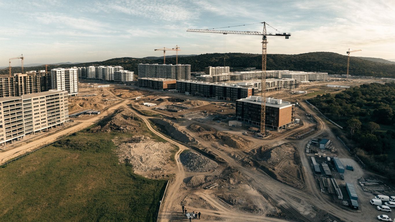
Aerial imagery can show the overall arrangement of a site, including access routes, work areas, stockpiles and visible changes to structures. A planned sequence of images gives the team a reference point for later reviews, while ground-level photographs can add detail where an aerial view cannot resolve a specific condition. Together, these records help people understand what was visible at a particular time, without treating an image as a substitute for an inspection.
A practical drone monitoring plan sets out what the team intends to capture and how it will check the resulting imagery. That might include defining priority areas, keeping viewpoints consistent and recording when conditions have changed. The result is a more useful visual record than a collection of unrelated images.
The difference between progress monitoring and basic site photography
Basic site photography often records a moment or a particular feature. Monitoring adds a repeatable method: captures are scheduled, framed and reviewed against earlier records or project information. That makes it easier to distinguish a genuine change from a difference in angle, weather or image quality.
The method need not be complicated, but consistent capture conditions make comparisons more meaningful. Teams should note the date, intended coverage and any limitations on each capture. Where the purpose is broader site visibility, construction drone imagery can complement other visual records rather than replace them.
When drone data adds the most value to a project
Aerial records tend to be valuable when a site is changing quickly, when work is spread across a large footprint or when stakeholders cannot visit regularly. They can also help teams prepare for milestone reviews by providing a shared view of visible site conditions. A general overview of drones in construction can help teams consider where aerial imagery may fit alongside surveying, planning and safety work.
The value depends on the question being asked. If a team needs to confirm a concealed installation or assess workmanship at close range, an aerial image alone will not answer it. Match the capture method to the decision, and record where additional inspection or measurement is needed.
Key benefits for construction teams
A regular visual record gives project teams another way to check what has changed and explain that change to others. It can support programme conversations, coordination and reporting, particularly when people are working from different locations. The images are most useful when reviewed with the people responsible for the work, rather than circulated without context. They remain supporting evidence, not a replacement for professional judgement.

Comparing completed work with programme milestones
A capture can be reviewed against planned milestones to discuss whether visible work appears to be progressing as expected. It does not, by itself, establish that a task is complete or confirm quality; teams should check the relevant records and speak with the people accountable for the work. A comparison is clearest when the site image and the milestone refer to the same area and date range.
Different information sources answer different questions, so a simple comparison framework helps keep the review grounded:
| Evidence | Useful comparison | What it cannot establish alone |
|---|---|---|
| Repeat aerial captures | Visible change across site areas | Work quality or concealed conditions |
| Programme milestones | Planned timing against reported status | Whether physical work meets specification |
| Site inspection records | Recorded observations and follow-up | Overall site change between visits |
| Design information | Intended arrangement against visible conditions | Final acceptance or compliance |
Used together, these records give the team a clearer basis for follow-up. For instance, a visible difference from the expected sequence can prompt a question for the site supervisor rather than an unsupported conclusion about delay.
Improving communication with clients and subcontractors
A shared, dated image can make a project update easier to follow, especially for people who have not recently visited the site. It can show the context around an area of work and help frame a specific question for a subcontractor or client. Construction Time Lapse Specialists provides aerial photography as part of its visual services, which can contribute to project records and stakeholder communication.
Images can also have a life beyond routine reporting: contractors may use project photos and videos when presenting their work or preparing bids. A guide to contractor marketing discusses those uses, while the monitoring record itself should remain accurate and clearly dated. Keeping the intended audience in mind helps teams share only the detail that is useful to them.
Spotting delays, rework and site coordination issues earlier
A sequence of captures may make a stalled work area or a change in site access easier to notice during routine review. It can also help teams raise coordination questions while there is still time to investigate them. However, an image rarely explains why a condition has occurred, so a supervisor or relevant trade should verify the issue on site.
The same caution applies when assessing design changes. Architectural elements such as commercial shade systems have their own selection and installation considerations; a visual comparison can help locate the relevant area, but the project team still needs to consult the design and site records. Treating imagery as a prompt for a focused check keeps conclusions proportionate to the evidence.
How to plan drone data capture
A useful capture plan starts with the decisions the project team wants to support. From there, define which areas need coverage, how often to return and who will review the results. Repeatability is more important than flying frequently without a clear purpose. The approach should also account for site access, operating conditions and applicable aviation requirements.
Setting capture frequency around project needs
Capture frequency should reflect the pace and risk of change, the reporting cycle and the effort required to review each set of images. A busy phase may call for more frequent records than a stable period, while a milestone review may justify a capture timed to a particular stage. Agree the schedule with the people who will use the evidence, and adjust it when the programme changes.
Avoid collecting imagery simply because a calendar says it is time. A good schedule makes each capture answer a useful question, such as whether a work area has changed since the last review. For practical guidance on planning drone photography, define deliverables and repeatable timing before deciding how to capture the site.
Choosing flight paths, viewpoints and image overlap
Flight paths and viewpoints should provide coverage of the areas relevant to the project, while respecting site boundaries, people and operating rules. Where comparisons matter, returning to similar viewpoints makes changes easier to assess. The person planning the capture should also consider whether the intended output requires overlapping images and whether any obstructions or restricted areas will limit coverage.
A simple capture brief can record the details that help each flight serve its purpose:
- Identify the work zones and features that need to be visible.
- Note repeat viewpoints and any areas that require a closer view.
- Record the expected image outputs and review date.
- Mark access constraints, hazards and locations to avoid.
This brief gives the pilot and project team a common reference, while leaving room to adapt if site conditions change. It also helps reviewers understand what the imagery was meant to show.
Preparing the site, crew and equipment for each flight
Before a flight, confirm who is responsible for authorising access, coordinating with site personnel and checking that the planned operation is appropriate. The crew should know the capture area, timing and any active work that could affect safe operation. Equipment checks and a clear plan for storing and transferring the images help avoid preventable gaps in the record.
Construction Time Lapse Specialists offers drone imaging and high-resolution photography, alongside construction time-lapse cameras. Where a project needs more than one visual perspective, teams can consider how aerial records fit with the wider site documentation plan. Preparation should be specific to the location and operation, not copied unchanged from another site.
Turning drone imagery into useful progress data
Images become useful project information when they are organised, interpreted and shared with a clear purpose. Depending on the capture method and the work required, a team may use individual photographs, stitched imagery or 3D representations. Each output has limits, so the intended use should guide what is produced and how it is checked. A consistent naming and filing process also makes later comparisons easier.

Creating orthomosaics and 3D site models
Aerial image processing can combine multiple captures into mapped or modelled outputs, where the source imagery and processing support that result. An orthomosaic can provide a joined view of an area, while a 3D model can help people inspect site form from different perspectives. These outputs are not interchangeable, and the team should confirm that the chosen deliverable is suitable for its intended use.
Before relying on a processed output, check that its coverage and quality are appropriate and record any gaps. If a project needs measurements or survey-grade information, agree the required accuracy and validation method with a suitably qualified provider. A compelling visual model is not automatically a verified measurement.
Comparing current conditions with designs and previous captures
Comparisons work best when dates, locations and reference information are clear. Teams can review current imagery beside an earlier capture or relevant design information, then note where a closer inspection is warranted. For example, design features such as architectural shade systems may be checked against the intended location and project documentation, with any apparent discrepancy confirmed through normal site processes.
The same evidence discipline applies in other fields, even where the subject matter differs. A review of embryo transfer research, for example, concerns a distinct evidence base and decision context; it is a reminder not to treat findings as transferable without checking what they actually address. For construction, that means keeping each comparison tied to the right drawing, revision and date.
Sharing annotated findings through project reporting tools
A useful report makes the finding easy to locate and gives readers enough context to act. Add a date, area reference and concise annotation, then distinguish an observed condition from a question or proposed follow-up. Where the imagery has limitations, state them rather than letting readers assume that the view covers every relevant detail.
Keep the reporting format familiar to the project team, whether that is a shared visual record or an established project reporting tool. Clear annotations help stakeholders understand what they are looking at without turning a photograph into a claim it cannot support. This is particularly useful when reporting on public projects, where community-led health research planning is a separate example of structured consultation and stated priorities, not a construction monitoring method.
Integrating monitoring into project workflows
Monitoring works best when it is part of ordinary project routines rather than a separate stream of images. The team needs to know who captures the data, who checks it and how findings reach people who can respond. Agreeing those steps early reduces uncertainty when a capture reveals something that needs attention. The workflow should fit existing reporting and document-control practices.
Assigning responsibilities for capture, review and reporting
Give each stage a clear owner: planning the capture, coordinating site access, reviewing the resulting imagery and recording follow-up actions. The person who flies or arranges a flight may not be the right person to interpret programme implications, so establish who can validate a finding. A defined review date helps ensure that evidence does not sit unused in a folder.
Keep the record of decisions with the project’s normal documentation. That way, teams can trace what was observed, who reviewed it and what action followed. Clear responsibility also helps distinguish an image-based observation from a formal inspection or approval.
Connecting drone outputs with schedules and building information models
Drone imagery can be considered alongside programme information and building information models where formats and workflows allow. The team should agree which design revision or schedule baseline it is using, and how a visual observation will be recorded against that reference. A comparison can identify an area for investigation, but the image does not automatically update a model or verify installed work.
A repeatable process is especially useful when several disciplines contribute to a project. Define where the output will be stored, how it will be named and who can access it. Those decisions make it easier for teams to use a common record without blurring the boundaries between visual evidence and validated project data.
Defining KPIs that show whether monitoring is working
Choose measures that reflect whether the process is helping the team, not just how many images it produces. Useful indicators could include whether planned captures are completed, whether reviews occur on time and whether identified questions are assigned for follow-up. Set a baseline and review the measures periodically, adjusting the capture plan if the effort is not producing useful information.
The right indicators depend on the project’s purpose and reporting obligations. A public programme such as the health inequities research roadmap has different goals and consultation requirements from a construction job, so avoid borrowing measures without considering their context. For site monitoring, keep the link between each measure and a practical project decision clear.
Managing safety, compliance and data quality
A reliable visual record depends on safe operations, appropriate permissions and consistent handling of information. Requirements can vary with the location, airspace, site rules and planned operation, so teams should verify them before each flight rather than assume a familiar route is automatically permitted. Data quality also depends on conditions that can change from one capture to the next. A short pre-flight and post-capture review helps make those limits visible.
Meeting aviation rules and site safety requirements
Check the applicable aviation rules, site procedures and permissions before planning a flight, and ensure responsibilities are understood by the operator and site team. The operation should account for people, equipment, active work zones and any restrictions relevant to the location. Australian teams can consult a CASA compliance guide as part of checking the requirements that apply to their circumstances.
Site coordination matters as much as the flight plan. Notify relevant personnel, agree how work areas will be managed during capture and stop or reschedule if conditions make the operation unsuitable. The project’s safety processes remain in force throughout.
Protecting worker privacy and project information
Plan the capture to collect only the imagery needed for the project purpose. Consider where workers may appear, who can access the files and how long records should be retained under project requirements. A simple access and storage policy can reduce accidental sharing of sensitive images or project details.
Camera placement and viewing angles also influence what is recorded. General advice on home surveillance visibility addresses a different setting, but the underlying planning question—what an image captures and who can view it—also deserves attention on a construction site. Apply the project’s own privacy and information-handling rules rather than assuming that every visible detail should be retained or circulated.
Accounting for weather, visibility and inconsistent capture conditions
Weather, light, dust and site activity can affect what a camera records and whether the capture can proceed safely. Record conditions that materially change visibility or coverage, and avoid treating two images as directly comparable when their differences may be caused by those conditions. If an area is obscured, note the limitation and plan a suitable follow-up.
Review each set of imagery for missing areas, blur and unexpected changes in viewpoint before sharing it. Construction Time Lapse Specialists provides 4K cameras, remote monitoring and expert support for construction time-lapse projects; for any visual capture method, a documented review helps keep the record useful and its limitations clear.
Conclusion
Drone construction progress monitoring is most effective when repeatable capture, careful interpretation and clear responsibilities come together in the project’s normal reporting process. Use aerial imagery to guide questions and share site context, while relying on appropriate inspections and qualified judgement to confirm important findings. For broader visual coverage, explore camera options from Construction Time Lapse Specialists for construction projects.